
Topografische kaart Ballsville
Interactieve kaart
Klik op de kaart om de hoogte weer te geven.
Over deze kaart
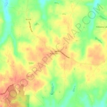
Naam: Topografische kaart Ballsville, hoogte, reliëf.
Locatie: Ballsville, Powhatan County, Virginia, United States (37.47845 -78.08775 37.51845 -78.04775)
Gemiddelde hoogte: 102 m
Minimale hoogte: 71 m
Maximale hoogte: 123 m
Andere topografische kaarten
Klik op een kaart om zijn topografie, zijn hoogte en zijn reliëf te bekijken.
Michaux
United States > Virginia > Powhatan County
Michaux, Powhatan County, Virginia, 23014, United States
Gemiddelde hoogte: 77 m
Tobaccoville
United States > Virginia > Powhatan County
Tobaccoville, Powhatan County, Virginia, United States
Gemiddelde hoogte: 106 m
Pilkinton
United States > Virginia > Powhatan County
Pilkinton, Powhatan County, Virginia, United States
Gemiddelde hoogte: 80 m
Chestnut Oaks
United States > Virginia > Powhatan County
Chestnut Oaks, Powhatan County, Virginia, United States
Gemiddelde hoogte: 99 m
Moseley
United States > Virginia > Powhatan County
Moseley, Powhatan County, Virginia, United States
Gemiddelde hoogte: 95 m
Powhatan
United States > Virginia > Powhatan County > Powhatan
Powhatan, Powhatan County, Virginia, 23139, United States
Gemiddelde hoogte: 102 m