
Topografische kaart Walker Bay Nature Reserve
Interactieve kaart
Klik op de kaart om de hoogte weer te geven.
Over deze kaart
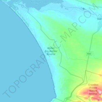
Naam: Topografische kaart Walker Bay Nature Reserve, hoogte, reliëf.
Gemiddelde hoogte: 54 m
Minimale hoogte: -2 m
Maximale hoogte: 501 m
Andere topografische kaarten
Klik op een kaart om zijn topografie, zijn hoogte en zijn reliëf te bekijken.
Overstrand Ward 8
RSA > Western Cape > Overstrand Local Municipality
Overstrand Ward 8, Overstrand Local Municipality, Overberg District Municipality, Western Cape, RSA
Gemiddelde hoogte: 144 m
Overstrand Ward 10
RSA > Western Cape > Overstrand Local Municipality
Overstrand Ward 10, Overstrand Local Municipality, Overberg District Municipality, Western Cape, 7141, RSA
Gemiddelde hoogte: 213 m
Maanschynkop Nature Reserve
RSA > Western Cape > Overstrand Local Municipality
Maanschynkop Nature Reserve, R43, Overstrand Ward 3, Overstrand Local Municipality, Overberg District Municipality, Western Cape, 7210, RSA
Gemiddelde hoogte: 538 m
Rooiels River
RSA > Western Cape > Overstrand Local Municipality
Rooiels River, Overstrand Local Municipality, Overberg District Municipality, Western Cape, RSA
Gemiddelde hoogte: 103 m
Fernkloof Nature Reserve
RSA > Western Cape > Overstrand Local Municipality
Fernkloof Nature Reserve, Rotary Way Extension, Overstrand Ward 3, Overstrand Local Municipality, Overberg District Municipality, Western Cape, 7200, RSA
Gemiddelde hoogte: 237 m
Three Sisters
RSA > Western Cape > Overstrand Local Municipality
Three Sisters, Overstrand Local Municipality, Overberg District Municipality, Western Cape, 7195, RSA
Gemiddelde hoogte: 306 m
Salmonsdam Nature Reserve
RSA > Western Cape > Overstrand Local Municipality
Salmonsdam Nature Reserve, Salmonsdam Nature Reserve 4x4 Trail, Cape Agulhas Ward 1, Overstrand Local Municipality, Overberg District Municipality, Western Cape, RSA
Gemiddelde hoogte: 343 m
Boesmans River
RSA > Western Cape > Overstrand Local Municipality
Boesmans River, Overstrand Local Municipality, Overberg District Municipality, Western Cape, 7271, RSA
Gemiddelde hoogte: 121 m
Quoin Point Nature Reserve
RSA > Western Cape > Overstrand Local Municipality
Quoin Point Nature Reserve, R43, Overstrand Ward 11, Overstrand Local Municipality, Overberg District Municipality, Western Cape, RSA
Gemiddelde hoogte: 12 m