
Topografische kaart Northfield
Interactieve kaart
Klik op de kaart om de hoogte weer te geven.
Over deze kaart
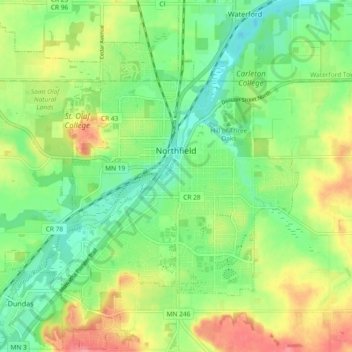
Naam: Topografische kaart Northfield, hoogte, reliëf.
Locatie: Northfield, Rice County, Minnesota, 55057, United States (44.42084 -93.22144 44.48590 -93.12889)
Gemiddelde hoogte: 300 m
Minimale hoogte: 268 m
Maximale hoogte: 347 m
According to the United States Census Bureau, the city has an area of 8.61 square miles (22.30 km2); 8.56 square miles (22.17 km2) is land and 0.05 square miles (0.13 km2) is water. The peak elevation is about 912 feet.
Andere topografische kaarten
Klik op een kaart om zijn topografie, zijn hoogte en zijn reliëf te bekijken.
Faribault
United States > Minnesota > Rice County
Faribault, Rice County, Minnesota, 55021, United States
Gemiddelde hoogte: 325 m
Nerstrand Big Woods State Park
United States > Minnesota > Rice County
Nerstrand Big Woods State Park, Rice County, Minnesota, United States
Gemiddelde hoogte: 356 m
Morristown
United States > Minnesota > Rice County
Morristown, Rice County, Minnesota, United States
Gemiddelde hoogte: 316 m
Hazelwood
United States > Minnesota > Rice County
Hazelwood, Rice County, Minnesota, United States
Gemiddelde hoogte: 316 m
Warsaw
United States > Minnesota > Rice County
Warsaw, Rice County, Minnesota, 55087, United States
Gemiddelde hoogte: 315 m
Shieldsville
United States > Minnesota > Rice County
Shieldsville, Rice County, Minnesota, United States
Gemiddelde hoogte: 333 m
Walcott
United States > Minnesota > Rice County
Walcott, Rice County, Minnesota, United States
Gemiddelde hoogte: 361 m
Veseli
United States > Minnesota > Rice County
Veseli, Rice County, Minnesota, United States
Gemiddelde hoogte: 327 m
Cannon City
United States > Minnesota > Rice County
Cannon City, Rice County, Minnesota, United States
Gemiddelde hoogte: 348 m
Lonsdale
United States > Minnesota > Rice County
Lonsdale, Rice County, Minnesota, 55046, United States
Gemiddelde hoogte: 336 m
Northfield
United States > Minnesota > Rice County
Northfield, Dundas, Rice County, Minnesota, 55057, United States
Gemiddelde hoogte: 300 m
Hidden Falls
United States > Minnesota > Rice County
Hidden Falls, Rice County, Minnesota, 55053, United States
Gemiddelde hoogte: 353 m