
Topografische kaart Bozeman
Interactieve kaart
Klik op de kaart om de hoogte weer te geven.
Over deze kaart
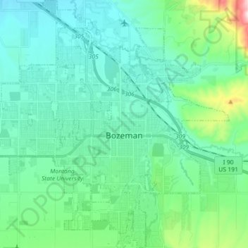
Naam: Topografische kaart Bozeman, hoogte, reliëf.
Locatie: Bozeman, Gallatin County, Montana, United States (45.63479 -111.11982 45.73326 -110.98424)
Gemiddelde hoogte: 1.495 m
Minimale hoogte: 1.392 m
Maximale hoogte: 1.974 m
Bozeman is located at an elevation of 4,820 feet or 1,470 metres. The Bridger Mountains are to the north-northeast, the Tobacco Root Mountains to the west-south-west, the Big Belt Mountains and Horseshoe Hills to the northwest, the Hyalite Peaks of the northern Gallatin Range to the south and the Spanish Peaks of the northern Madison Range to the south-southwest. Bozeman is east of the continental divide, and Interstate 90 passes through the city. It is 84 miles (135 km) east of Butte, 125 miles (201 km) west of Billings, and 93 miles (150 km) north of Yellowstone National Park.
Andere topografische kaarten
Klik op een kaart om zijn topografie, zijn hoogte en zijn reliëf te bekijken.
Logan
United States > Montana > Gallatin County
Logan, Gallatin County, Montana, United States
Gemiddelde hoogte: 1.294 m
Three Forks
United States > Montana > Gallatin County
Three Forks, Gallatin County, Montana, United States
Gemiddelde hoogte: 1.249 m
Big Sky
United States > Montana > Gallatin County
Big Sky, Gallatin County, Montana, United States
Gemiddelde hoogte: 2.435 m
Bozeman
United States > Montana > Gallatin County > Bozeman
Bozeman, Gallatin County, Montana, 59715, United States
Gemiddelde hoogte: 1.679 m
West Yellowstone
United States > Montana > Gallatin County
West Yellowstone, Gallatin County, Montana, United States
Gemiddelde hoogte: 2.034 m