
Topografische kaart Bor
Interactieve kaart
Klik op de kaart om de hoogte weer te geven.
Over deze kaart
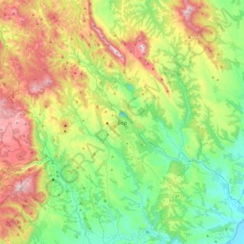
Naam: Topografische kaart Bor, hoogte, reliëf.
Gemiddelde hoogte: 474 m
Minimale hoogte: 116 m
Maximale hoogte: 1.147 m
Crni Vrh is a mountain 30 km from the city center. Highest peak has an elevation of 1,043 m (3,422 ft) above sea level. It has several ski tracks anda ski lift. The main ski track is 1,100 m long and has height span of 260 m. Just 16 km from the city center there is another mountain Stol. Its highest peak has an elevation of 1,156 meters above sea level. Like nearby Veliki Krš and Mali Krš, Stol has a number of pronounced karst formations. It is also a destination for mountaineering. It has a ski lift and ski trails. Mountain Rtanj in Boljevac municipality is 50 km away from Bor.
Andere topografische kaarten
Klik op een kaart om zijn topografie, zijn hoogte en zijn reliëf te bekijken.
Rajac
Serbia > Central Serbia > Bor Administrative District > Negotin Municipality
Rajac, Negotin Municipality, Bor Administrative District, Central Serbia, 19314, Serbia
Gemiddelde hoogte: 127 m
Negotin
Serbia > Central Serbia > Bor Administrative District > Negotin Municipality
Negotin, Negotin Municipality, Bor Administrative District, Central Serbia, 19300, Serbia
Gemiddelde hoogte: 86 m
Prahovo
Serbia > Central Serbia > Bor Administrative District > Negotin Municipality
Prahovo, Negotin Municipality, Bor Administrative District, Central Serbia, Serbia
Gemiddelde hoogte: 48 m
Donji Milanovac
Serbia > Central Serbia > Bor Administrative District > Majdanpek Municipality
Donji Milanovac, Majdanpek Municipality, Bor Administrative District, Central Serbia, Serbia
Gemiddelde hoogte: 243 m
Kladovo
Serbia > Central Serbia > Bor Administrative District > Kladovo Municipality
Kladovo, Kladovo Municipality, Bor Administrative District, Central Serbia, 19320, Serbia
Gemiddelde hoogte: 89 m