
Topografische kaart Manizales
Interactieve kaart
Klik op de kaart om de hoogte weer te geven.
Over deze kaart
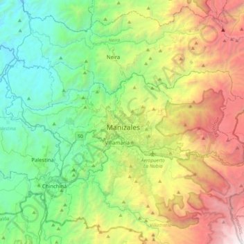
Naam: Topografische kaart Manizales, hoogte, reliëf.
Gemiddelde hoogte: 2.114 m
Minimale hoogte: 774 m
Maximale hoogte: 4.844 m
Manizales is the capital city of one of the smallest Colombian departments. The city is described as having an "abrupt topography", and lies on the Colombian Central Mountain Range (part of the longest continental mountain range, the Andes), with a great deal of ridgelines and steep slopes, which, combined with the seismic instability of the area, has required architectural adaptations and public works to make the city safer. Even though Manizales has this very difficult topography, there are many coffee plantations in its fertile lands. The city is located in the northern part of the Colombian Coffee-Growers Axis ("Eje Cafetero"), near the volcano Nevado del Ruiz, which has an altitude of 5,321 meters (17,457.3 ft).
Andere topografische kaarten
Klik op een kaart om zijn topografie, zijn hoogte en zijn reliëf te bekijken.
Cabecera Municipal La Dorada
Colombia > Caldas > Cabecera Municipal La Dorada
Cabecera Municipal La Dorada, La Dorada, Magdalena Caldense, Caldas, Colombia
Gemiddelde hoogte: 182 m
Palo negro
Palo negro, Carretera Panamericana, Camilo Torres, Comuna Universitaria, Manizales, Centrosur, Caldas, 176001, Colombia
Gemiddelde hoogte: 1.966 m
California Baja
Colombia > Caldas > Samaná > California Baja
California Baja, Samaná, Magdalena Caldense, Caldas, Colombia
Gemiddelde hoogte: 1.005 m