
Topografische kaart Ingham County
Interactieve kaart
Klik op de kaart om de hoogte weer te geven.
Over deze kaart
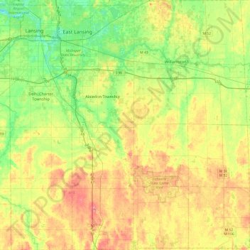
Naam: Topografische kaart Ingham County, hoogte, reliëf.
Locatie: Ingham County, Michigan, United States of America (42.42196 -84.60314 42.77660 -84.14060)
Gemiddelde hoogte: 278 m
Minimale hoogte: 246 m
Maximale hoogte: 319 m
The county consists of gently rolling hills with an elevation ranging between 800 and 1,000 feet above sea level. The highest point in the county is the top of Teaspoon Hill rising to a height of 1,056 feet above sea level 1.5 miles north of Leslie.
Andere topografische kaarten
Klik op een kaart om zijn topografie, zijn hoogte en zijn reliëf te bekijken.
Genesee County
United States of America > Michigan
Genesee County, Michigan, United States of America
Gemiddelde hoogte: 246 m
Ontonagon County
United States of America > Michigan
Ontonagon County, Michigan, United States of America
Gemiddelde hoogte: 334 m
Sanilac County
United States of America > Michigan
Sanilac County, Michigan, United States of America
Gemiddelde hoogte: 228 m
East Lansing
United States of America > Michigan > East Lansing > East Lansing
East Lansing, Ingham County, Michigan, United States of America
Gemiddelde hoogte: 261 m