
Topografische kaart West Pensacola
Interactieve kaart
Klik op de kaart om de hoogte weer te geven.
Over deze kaart
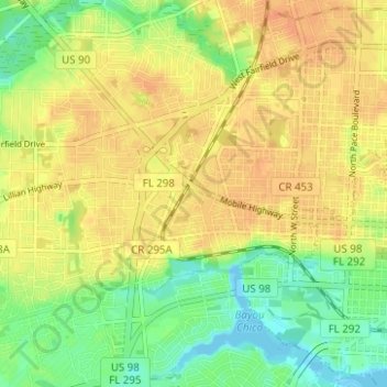
Naam: Topografische kaart West Pensacola, hoogte, reliëf.
Gemiddelde hoogte: 20 m
Minimale hoogte: -4 m
Maximale hoogte: 34 m
West Pensacola is located at 30°25′39″N 87°15′39″W / 30.42750°N 87.26083°W / 30.42750; -87.26083 (30.427547, -87.260720), or about 4 miles (6 km) west of downtown Pensacola. The elevation of the CDP is 76 feet above sea level.
Andere topografische kaarten
Klik op een kaart om zijn topografie, zijn hoogte en zijn reliëf te bekijken.
Bohemia
United States > Florida > Escambia County > Pensacola
Bohemia, Pensacola, Escambia County, Florida, 32504, United States
Gemiddelde hoogte: 15 m
Pensacola
United States > Florida > Escambia County > Pensacola
Pensacola, Escambia County, Florida, 32501, United States
Gemiddelde hoogte: 9 m
East Pensacola Heights
United States > Florida > Escambia County > Pensacola
East Pensacola Heights, Pensacola, Escambia County, Florida, 32520, United States
Gemiddelde hoogte: 8 m
Gull Point
United States > Florida > Escambia County > Pensacola > Gull Point
Gull Point, Pensacola, Escambia County, Florida, 32504, United States
Gemiddelde hoogte: 10 m