
Topografische kaart Outagamie County
Interactieve kaart
Klik op de kaart om de hoogte weer te geven.
Over deze kaart
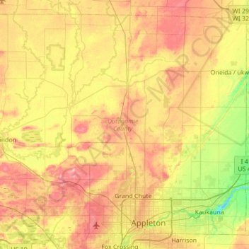
Naam: Topografische kaart Outagamie County, hoogte, reliëf.
Locatie: Outagamie County, Wisconsin, United States of America (44.24199 -88.73977 44.59061 -88.18998)
Gemiddelde hoogte: 241 m
Minimale hoogte: 183 m
Maximale hoogte: 305 m
Andere topografische kaarten
Klik op een kaart om zijn topografie, zijn hoogte en zijn reliëf te bekijken.
Middleton
United States of America > Wisconsin > Middleton
Middleton, Dane County, Wisconsin, 53562, United States of America
Gemiddelde hoogte: 297 m
Door County
United States of America > Wisconsin
Door County, Wisconsin, United States of America
Gemiddelde hoogte: 191 m
Gays Mills
United States of America > Wisconsin > Gays Mills
Gays Mills, Crawford County, Wisconsin, United States of America
Gemiddelde hoogte: 272 m
Waukesha County
United States of America > Wisconsin
Waukesha County, Wisconsin, United States of America
Gemiddelde hoogte: 272 m
Milwaukee County
United States of America > Wisconsin
Milwaukee County, Wisconsin, United States of America
Gemiddelde hoogte: 186 m