
Topografische kaart Coldcut
Interactieve kaart
Klik op de kaart om de hoogte weer te geven.
Over deze kaart
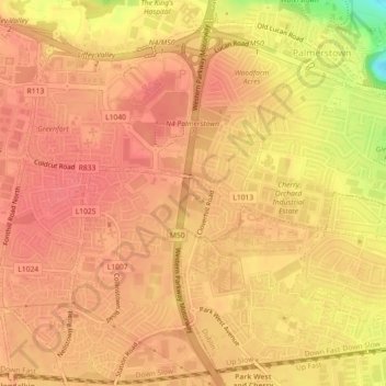
Naam: Topografische kaart Coldcut, hoogte, reliëf.
Gemiddelde hoogte: 56 m
Minimale hoogte: 8 m
Maximale hoogte: 70 m
Andere topografische kaarten
Klik op een kaart om zijn topografie, zijn hoogte en zijn reliëf te bekijken.
Palmerstown Village ED
Palmerstown Village ED, Dublin 20, South Dublin, County Dublin, Leinster, Ireland
Gemiddelde hoogte: 50 m
Redcowfarm
Redcowfarm, Palmerstown Village ED, Dublin 20, South Dublin, County Dublin, Leinster, Ireland
Gemiddelde hoogte: 45 m