
Topografische kaart Town of Shelburne
Interactieve kaart
Klik op de kaart om de hoogte weer te geven.
Over deze kaart
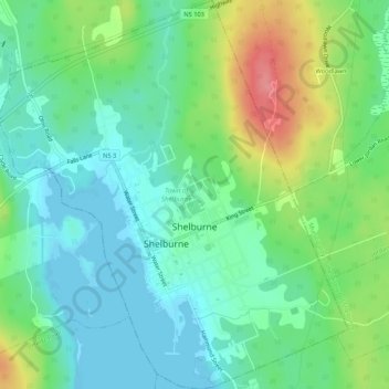
Naam: Topografische kaart Town of Shelburne, hoogte, reliëf.
Locatie: Town of Shelburne, Shelburne County, Nova Scotia, Canada (43.74952 -65.34439 43.78805 -65.29645)
Gemiddelde hoogte: 28 m
Minimale hoogte: -1 m
Maximale hoogte: 91 m
Andere topografische kaarten
Klik op een kaart om zijn topografie, zijn hoogte en zijn reliëf te bekijken.
Town of Clark's Harbour
Canada > Nova Scotia > Shelburne County
Town of Clark's Harbour, Shelburne County, Nova Scotia, Canada
Gemiddelde hoogte: 2 m
Stoney Island
Canada > Nova Scotia > Shelburne County
Stoney Island, Municipality of the District of Barrington, Shelburne County, Nova Scotia, B0W 1P0, Canada
Gemiddelde hoogte: 3 m
Canada Hill
Canada > Nova Scotia > Shelburne County > Canada Hill
Canada Hill, Municipality of the District of Shelburne, Shelburne County, Nova Scotia, B0T 1L0, Canada
Gemiddelde hoogte: 34 m
Churchover
Canada > Nova Scotia > Shelburne County
Churchover, Municipality of the District of Shelburne, Shelburne County, Nova Scotia, B0T 1W0, Canada
Gemiddelde hoogte: 27 m
Ingomar
Canada > Nova Scotia > Shelburne County
Ingomar, Municipality of the District of Shelburne, Shelburne County, Nova Scotia, B0T 1W0, Canada
Gemiddelde hoogte: 5 m
Shelburne
Canada > Nova Scotia > Shelburne County > Shelburne
Shelburne, Town of Shelburne, Shelburne County, Nova Scotia, Canada
Gemiddelde hoogte: 28 m