
Topografische kaart Cuddalore
Interactieve kaart
Klik op de kaart om de hoogte weer te geven.
Cuddalore
Cuddalore is located at 11°45′N 79°45′E / 11.75°N 79.75°E / 11.75; 79.75. It has an average elevation of 6 m (20 ft). The land is completely flat with large black and alluvial soil inland and coarse sand near the seashore. The sandstone deposits in the town are popular. The Pennayar River runs north of the town, while Gadilam River runs across it. Cuddalore is situated at 200 km (120 mi) from the state capital Chennai and 18 km (11 mi) from Puducherry, the neighbouring union territory.
Over deze kaart
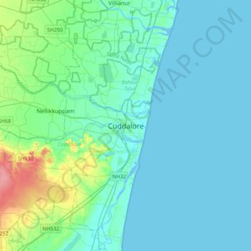
Naam: Topografische kaart Cuddalore, hoogte, reliëf.
Locatie: Cuddalore, Cuddalore District, Tamil Nadu, 607001, India (11.59643 79.60346 11.91643 79.92346)
Gemiddelde hoogte: 11 m
Minimale hoogte: -4 m
Maximale hoogte: 72 m