
Topografische kaart Lusaka
Interactieve kaart
Klik op de kaart om de hoogte weer te geven.
Over deze kaart
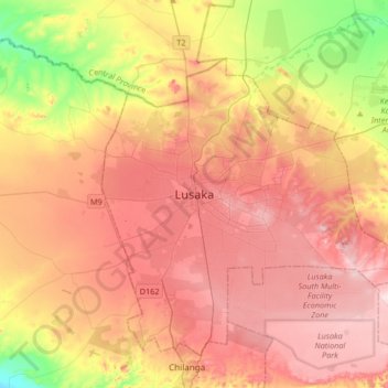
Naam: Topografische kaart Lusaka, hoogte, reliëf.
Locatie: Lusaka, Lusaka District, Lusaka Province, 10101, Zambia (-15.57641 28.12248 -15.25641 28.44248)
Gemiddelde hoogte: 1.227 m
Minimale hoogte: 1.064 m
Maximale hoogte: 1.350 m
Lusaka (/luːˈsɑːkə/; loo-SAH-kə) is the capital and largest city of Zambia. It is one of the fastest-developing cities in southern Africa. Lusaka is in the southern part of the central plateau at an elevation of about 1,279 metres (4,196 ft). As of 2019, the city's population was about 3.3 million, while the urban population is estimated at 2.5 million in 2018. Lusaka is the centre of both commerce and government in Zambia and connects to the country's four main highways heading north, south, east and west. English is the official language of the city administration, while Bemba, Tonga, Lenje, Soli, Lozi and Nyanja are the commonly spoken street languages.
Andere topografische kaarten
Klik op een kaart om zijn topografie, zijn hoogte en zijn reliëf te bekijken.
Rufunsa District
Rufunsa District, Lusaka Province, Zambia
Gemiddelde hoogte: 796 m
Zambezi Escarpment
Zambia > Lusaka Province > Lusaka
Zambezi Escarpment, Road to Lower Zambezi National Park, Lusaka, Lusaka Province, 10101, Zambia
Gemiddelde hoogte: 726 m
Lower Zambezi National Park
Lower Zambezi National Park, Lusaka Province, Zambia
Gemiddelde hoogte: 677 m
Kafue District
Kafue District, Lusaka Province, Zambia
Gemiddelde hoogte: 925 m
Chongwe River
Chongwe River, Lusaka Province, 10101, Zambia
Gemiddelde hoogte: 1.013 m
Chiawa
Zambia > Lusaka Province > Chiawa
Chiawa, Kafue District, Lusaka Province, Zambia
Gemiddelde hoogte: 376 m
Kanyemba Island
Kanyemba Island, Kafue District, Lusaka Province, Zambia
Gemiddelde hoogte: 372 m