
Topografische kaart Mount Mitchell
Interactieve kaart
Klik op de kaart om de hoogte weer te geven.
Over deze kaart
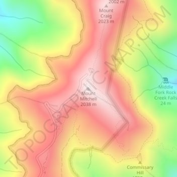
Naam: Topografische kaart Mount Mitchell, hoogte, reliëf.
Locatie: Mount Mitchell, Yancey County, North Carolina, VS (35.76491 -82.26517 35.76501 -82.26507)
Gemiddelde hoogte: 1.743 m
Minimale hoogte: 1.355 m
Maximale hoogte: 2.019 m
Andere topografische kaarten
Klik op een kaart om zijn topografie, zijn hoogte en zijn reliëf te bekijken.
Buies Creek
VS > North Carolina > Buies Creek
Buies Creek, Harnett County, North Carolina, 27506, VS
Gemiddelde hoogte: 61 m