
Topografische kaart Zemplín
Interactieve kaart
Klik op de kaart om de hoogte weer te geven.
Over deze kaart
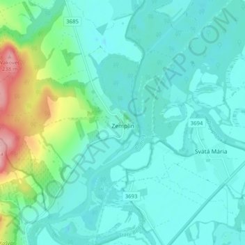
Naam: Topografische kaart Zemplín, hoogte, reliëf.
Gemiddelde hoogte: 116 m
Minimale hoogte: 87 m
Maximale hoogte: 242 m
The village lies at an altitude of 106 metres and covers an area of 14,67 km². It is located near the junction point of the rivers Ondava and Latorica (tributaries of the river Bodrog) in eastern Slovakia.
Andere topografische kaarten
Klik op een kaart om zijn topografie, zijn hoogte en zijn reliëf te bekijken.
Borša
Slovakia > Region of Košice > District of Trebišov
Borša, District of Trebišov, Region of Košice, Eastern Slovakia, 076 32, Slovakia
Gemiddelde hoogte: 114 m
Kysta
Slovakia > Region of Košice > District of Trebišov
Kysta, District of Trebišov, Region of Košice, Eastern Slovakia, Slovakia
Gemiddelde hoogte: 177 m
Boťany
Slovakia > Region of Košice > District of Trebišov
Boťany, District of Trebišov, Region of Košice, Eastern Slovakia, 076 43, Slovakia
Gemiddelde hoogte: 101 m
Borša
Slovakia > Region of Košice > District of Trebišov > Borša > Borša
Borša, District of Trebišov, Region of Košice, Eastern Slovakia, 076 32, Slovakia
Gemiddelde hoogte: 110 m