
Topografische kaart The Municipal District of Greystones
Interactieve kaart
Klik op de kaart om de hoogte weer te geven.
Over deze kaart
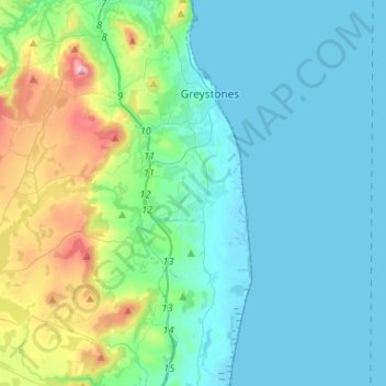
Naam: Topografische kaart The Municipal District of Greystones, hoogte, reliëf.
Gemiddelde hoogte: 89 m
Minimale hoogte: -1 m
Maximale hoogte: 487 m
Andere topografische kaarten
Klik op een kaart om zijn topografie, zijn hoogte en zijn reliëf te bekijken.
Glendalough
Glendalough, The Municipal District of Wicklow, County Wicklow, Leinster, A98 X9C1, Ierland
Gemiddelde hoogte: 284 m
Glenmacnass River
Glenmacnass River, Glendalough ED, The Municipal District of Wicklow, County Wicklow, Leinster, Ierland
Gemiddelde hoogte: 434 m