
Topografische kaart Avilla
Interactieve kaart
Klik op de kaart om de hoogte weer te geven.
Over deze kaart
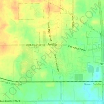
Naam: Topografische kaart Avilla, hoogte, reliëf.
Locatie: Avilla, Noble County, Indiana, United States (41.35116 -85.25061 41.37653 -85.21778)
Gemiddelde hoogte: 294 m
Minimale hoogte: 275 m
Maximale hoogte: 309 m
Andere topografische kaarten
Klik op een kaart om zijn topografie, zijn hoogte en zijn reliëf te bekijken.
Chain O'Lakes State Park
United States > Indiana > Noble County
Chain O'Lakes State Park, 9, Noble County, Indiana, United States
Gemiddelde hoogte: 290 m
Kendallville
United States > Indiana > Noble County
Kendallville, Noble County, Indiana, 46755, United States
Gemiddelde hoogte: 303 m
Albion
United States > Indiana > Noble County
Albion, Noble County, Indiana, United States
Gemiddelde hoogte: 285 m
Ligonier
United States > Indiana > Noble County
Ligonier, Noble County, Indiana, United States
Gemiddelde hoogte: 277 m
Kendallville
United States > Indiana > Noble County > Kendallville > Kendallville
Kendallville, Noble County, Indiana, 46755, United States
Gemiddelde hoogte: 304 m
Wolcottville
United States > Indiana > Noble County
Wolcottville, Noble County, Indiana, United States
Gemiddelde hoogte: 287 m