
Topografische kaart Vagamon
Klik op de kaart om de hoogte weer te geven.
Vagamon
Vagamon, due to its elevation and climate, has a unique ecosystem, leading to the emergence of rich natural vegetation, plant species, shola forests etc. From the early 20th century plantation crops like tea, coffee started. Vagamon hills are home to less explored flora and fauna. A faunal diversity study conducted by Dr Pratheesh Mathew recorded 112 species of moths from 16 families under eight superfamilies and has become the prominent faunal diversity study in this area. The author has also recorded sightings of many species of insects, annelids, amphibians, lizards, snakes, birds and mammals. A wide variety of flowering and non-flowering plants, including rare Cycas species, has also been noted. The ongoing faunal and floral surveys are expected to shed light on the richness of biodiversity at this location. The flourishing tourism and related developments are predicted to have a negative impact on the flora and fauna of this region.
Over deze kaart
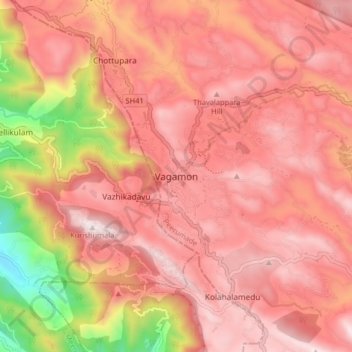
Naam: Topografische kaart Vagamon, hoogte, reliëf.
Locatie: Vagamon, Peerumade, Idukki, Kerala, 685503, India (9.64860 76.86686 9.72860 76.94686)
Gemiddelde hoogte: 866 m
Minimale hoogte: 179 m
Maximale hoogte: 1.190 m
Andere topografische kaarten
Klik op een kaart om zijn topografie, zijn hoogte en zijn reliëf te bekijken.
Periyar National Park Tiger Reserve
Periyar National Park lies in the middle of a mountainous area of the Cardamom Hills. In the north : The boundary commences from the point nearest to the Medaganam in the interstate boundary up to Vellimalai. and the east Thence the boundary follows the inter-state boundary from Vellimalai to Kallimalai Peak…
Gemiddelde hoogte: 929 m