
Topografische kaart DeSoto
Interactieve kaart
Klik op de kaart om de hoogte weer te geven.
Over deze kaart
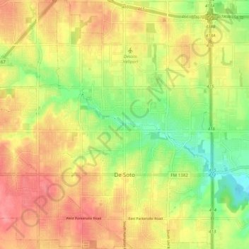
Naam: Topografische kaart DeSoto, hoogte, reliëf.
Locatie: DeSoto, Dallas County, Texas, 75115, United States (32.56500 -96.90846 32.64764 -96.82236)
Gemiddelde hoogte: 198 m
Minimale hoogte: 153 m
Maximale hoogte: 235 m
Andere topografische kaarten
Klik op een kaart om zijn topografie, zijn hoogte en zijn reliëf te bekijken.
Farmers Branch
United States > Texas > Dallas County
Farmers Branch, Dallas County, Texas, 75234, United States
Gemiddelde hoogte: 150 m
Duncanville
United States > Texas > Dallas County
Duncanville, Dallas County, Texas, United States
Gemiddelde hoogte: 213 m
Dallas
United States > Texas > Dallas County
Dallas, Dallas County, Texas, United States
Gemiddelde hoogte: 160 m
Irving
United States > Texas > Dallas County > Irving
Irving, Dallas County, Texas, 75061, United States
Gemiddelde hoogte: 162 m
Mesquite
United States > Texas > Dallas County > Mesquite
Mesquite, Dallas County, Texas, 75149, United States
Gemiddelde hoogte: 145 m
Garland
United States > Texas > Dallas County > Garland
Garland, Dallas County, Texas, 75040, United States
Gemiddelde hoogte: 164 m
Dallas
United States > Texas > Dallas County > Dallas
Dallas, Dallas County, Texas, 75242, United States
Gemiddelde hoogte: 158 m
Highland Park
United States > Texas > Dallas County
Highland Park, Dallas County, Texas, 75205, United States
Gemiddelde hoogte: 165 m
Grand Prairie
United States > Texas > Dallas County
Grand Prairie, Dallas County, Texas, United States
Gemiddelde hoogte: 183 m
Irving
United States > Texas > Dallas County
Irving, Dallas County, Texas, United States
Gemiddelde hoogte: 149 m
Cedar Hill
United States > Texas > Dallas County
Cedar Hill, Dallas County, Texas, 75104, United States
Gemiddelde hoogte: 214 m