
Topografische kaart Los Katíos National Park
Interactieve kaart
Klik op de kaart om de hoogte weer te geven.
Over deze kaart
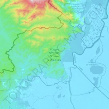
Naam: Topografische kaart Los Katíos National Park, hoogte, reliëf.
Locatie: Los Katíos National Park, Urabá, Chocó, RAP Pacífico, Colombia (7.67867 -77.39808 7.96955 -77.00584)
Gemiddelde hoogte: 146 m
Minimale hoogte: -2 m
Maximale hoogte: 1.354 m
Los Katíos National Natural Park (Spanish: Parque Nacional Natural (PNN) Los Katíos) is a protected area located in northwest Colombia which covers about 720 km2 (280 sq mi). The elevation ranges between 50 and 600 m (160 and 1,970 ft). It is a part of the Darién Gap, a densely forested area shared by Panama and Colombia, and is contiguous with the Darién National Park in Panama. The Pan-American Highway, when completed as proposed, would pass near or through Los Katíos. The park was declared a UNESCO World Heritage Site in 1994 due to the extraordinary diversity of plant and animal species represented.
Andere topografische kaarten
Klik op een kaart om zijn topografie, zijn hoogte en zijn reliëf te bekijken.
Pizarro
Colombia > Chocó > Bajo Baudó (Pizarro)
Pizarro, Bajo Baudó (Pizarro), Pacífico Sur, Chocó, Colombia
Gemiddelde hoogte: 15 m
Bahía Solano (Mutis)
Bahía Solano (Mutis), Pacífico Norte, Chocó, RAP Pacífico, Colombia
Gemiddelde hoogte: 130 m
Docordó
Colombia > Chocó > El Litoral del San Juan
Docordó, El Litoral del San Juan, Pacífico Sur, Chocó, Colombia
Gemiddelde hoogte: 7 m
Huaca
Colombia > Chocó > Bahía Solano (Mutis)
Huaca, Bahía Solano (Mutis), Pacífico Norte, Chocó, Colombia
Gemiddelde hoogte: 47 m