
Topografische kaart Pfäfers
Interactieve kaart
Klik op de kaart om de hoogte weer te geven.
Over deze kaart
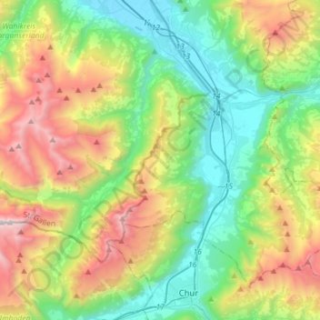
Naam: Topografische kaart Pfäfers, hoogte, reliëf.
Locatie: Pfäfers, Wahlkreis Sarganserland, Sankt Gallen, Switzerland (46.87289 9.24882 46.99710 9.53269)
Gemiddelde hoogte: 1.355 m
Minimale hoogte: 484 m
Maximale hoogte: 3.092 m
The municipality is located in the Sarganserland Wahlkreis. It stretches from the Taminatal south to the Kunkelspass and to the west into the high Calfeisen valley. The municipality has some of the largest elevation differences of any municipality (Tamina canyon 693 m (2,274 ft), Ringelspitz 3,247 m (10,653 ft)). It consists of the village of Pfäfers at the mouth of the Tamina Valley on a plateau above the Rhine river, the villages of Valens, Vasön and Vättis as well as the hamlets of St. Margrethenberg and Vadura.