
Doe een donatie
Rust jezelf uit voor je volgende avontuur:
Als Amazon-partner verdient deze site een commissie op in aanmerking komende aankopen, zonder extra kosten voor jou.
Topografische kaart Wausau
Klik op de kaart om de hoogte weer te geven.
Doe een donatie
Rust jezelf uit voor je volgende avontuur:
Als Amazon-partner verdient deze site een commissie op in aanmerking komende aankopen, zonder extra kosten voor jou.
Wausau
According to the United States Census Bureau, the city has a total area of 20.33 square miles (52.7 km2), of which 19.22 square miles (49.8 km2) is land and 1.11 square miles (2.9 km2) is water. The city is located at an altitude of 1,195 feet (364 m). Wausau is close to the center of the northern half of the Western Hemisphere. Just west of Wausau, 45°N meets 90°W (45°N 90°W / 45°N 90°W / 45; -90), which is exactly halfway between the equator and the north pole and a quarter of the way around the world from the prime meridian.
Doe een donatie
Rust jezelf uit voor je volgende avontuur:
Als Amazon-partner verdient deze site een commissie op in aanmerking komende aankopen, zonder extra kosten voor jou.
Over deze kaart
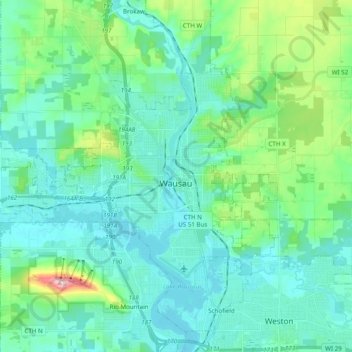
Naam: Topografische kaart Wausau, hoogte, reliëf.
Locatie: Wausau, Marathon County, Wisconsin, United States (44.91855 -89.76793 45.00644 -89.57292)
Gemiddelde hoogte: 394 m
Minimale hoogte: 351 m
Maximale hoogte: 585 m
Doe een donatie
Rust jezelf uit voor je volgende avontuur:
Als Amazon-partner verdient deze site een commissie op in aanmerking komende aankopen, zonder extra kosten voor jou.
Andere topografische kaarten
Klik op een kaart om zijn topografie, zijn hoogte en zijn reliëf te bekijken.
George W Mead State Wildlife Management Area
United States > Wisconsin > Marathon County > Town of Bergen
Gemiddelde hoogte: 343 m
Doe een donatie
Rust jezelf uit voor je volgende avontuur:
Als Amazon-partner verdient deze site een commissie op in aanmerking komende aankopen, zonder extra kosten voor jou.
Bypass Channel Wisconsin River
United States > Wisconsin > Marathon County > Wausau
Gemiddelde hoogte: 371 m