
Topografische kaart Pantelleria
Interactieve kaart
Klik op de kaart om de hoogte weer te geven.
Over deze kaart
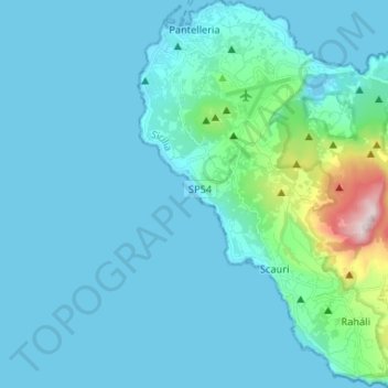
Naam: Topografische kaart Pantelleria, hoogte, reliëf.
Locatie: Pantelleria, Trapani, Sicily, 91017, Italy (36.73438 11.92586 36.83939 12.05684)
Gemiddelde hoogte: 83 m
Minimale hoogte: 0 m
Maximale hoogte: 824 m
Pantelleria has a subtropical Mediterranean climate (Köppen: Csa) characterized by very warm to hot, almost rainless and humid summers, very mild and frost-free winters, a powerful seasonal lag and a small diurnal temperature range. The constant sea breezes, moderate the daytime summer temperatures. Coastal Pantelleria (along with Lampedusa and coastal Malta) is one of the very few areas along the Mediterranean Sea coast, which have never recorded frost. Below freezing temperatures and snow only and sporadically occur at Montagna Grande and at higher elevations on the island. Despite the very dry summers and the fairly low annual precipitation, the dry season is noticeably shorter at four months, and the rainy season lasts at least for eight months.
Andere topografische kaarten
Klik op een kaart om zijn topografie, zijn hoogte en zijn reliëf te bekijken.
Alcamo Marina
Italy > Sicily > Trapani > Alcamo
Alcamo Marina, Alcamo, Trapani, Sicily, 91011, Italy
Gemiddelde hoogte: 46 m
Borgata Costiera
Italy > Sicily > Trapani > Mazara del Vallo
Borgata Costiera, Mazara del Vallo, Trapani, Sicily, 91026, Italy
Gemiddelde hoogte: 95 m
Mazara del Vallo
Mazara del Vallo, Trapani, Sicily, 91026, Italy
Gemiddelde hoogte: 49 m