
Topografische kaart Saint-Lieux-Lafenasse
Interactieve kaart
Klik op de kaart om de hoogte weer te geven.
Over deze kaart
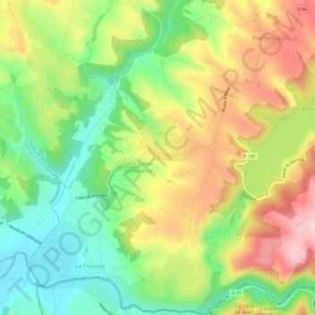
Naam: Topografische kaart Saint-Lieux-Lafenasse, hoogte, reliëf.
Gemiddelde hoogte: 292 m
Minimale hoogte: 194 m
Maximale hoogte: 411 m
Saint-Lieux-Lafenasse est située au nord-ouest de la montagne Noire, relief qui constitue l'extrémité méridionale du Massif central. La superficie de la commune est de 1 219 hectares. L'altitude de Saint-Lieux-Lafenasse varie entre 197 et 365 mètres.
Andere topografische kaarten
Klik op een kaart om zijn topografie, zijn hoogte en zijn reliëf te bekijken.
Le Trivalou
France > Occitanie > Tarn > Terre-de-Bancalié > Le Trivalou
Le Trivalou, Terre-Clapier, Terre-de-Bancalié, Albi, Tarn, Occitanie, France métropolitaine, 81120, France
Gemiddelde hoogte: 368 m
Ronel
France > Occitanie > Tarn > Terre-de-Bancalié
Ronel, Terre-de-Bancalié, Albi, Tarn, Occitanie, France métropolitaine, 81120, France
Gemiddelde hoogte: 290 m