
Topografische kaart Carbonton Heights
Interactieve kaart
Klik op de kaart om de hoogte weer te geven.
Over deze kaart
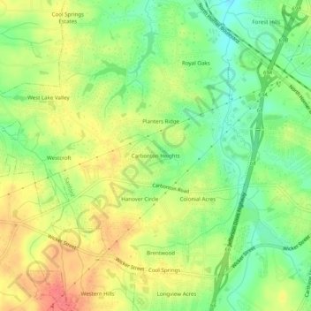
Naam: Topografische kaart Carbonton Heights, hoogte, reliëf.
Gemiddelde hoogte: 105 m
Minimale hoogte: 74 m
Maximale hoogte: 138 m
Andere topografische kaarten
Klik op een kaart om zijn topografie, zijn hoogte en zijn reliëf te bekijken.
Sunset Terrace
United States > North Carolina > Lee County > Sanford
Sunset Terrace, Sanford, Lee County, North Carolina, 27339, United States
Gemiddelde hoogte: 114 m
Colonial Acres
United States > North Carolina > Lee County > Sanford
Colonial Acres, Sanford, Lee County, North Carolina, 27339, United States
Gemiddelde hoogte: 106 m
Hanover Circle
United States > North Carolina > Lee County > Sanford
Hanover Circle, Sanford, Lee County, North Carolina, 27339, United States
Gemiddelde hoogte: 108 m
Brookwood
United States > North Carolina > Lee County > Sanford
Brookwood, Sanford, Lee County, North Carolina, 27339, United States
Gemiddelde hoogte: 105 m
Cool Springs Estates
United States > North Carolina > Lee County > Sanford > Cool Springs Estates
Cool Springs Estates, Sanford, Lee County, North Carolina, 27330, United States
Gemiddelde hoogte: 98 m
Forest Hills
United States > North Carolina > Lee County > Sanford > Forest Hills
Forest Hills, Sanford, Lee County, North Carolina, 27330, United States
Gemiddelde hoogte: 98 m
McCracken Heights
United States > North Carolina > Lee County > Sanford
McCracken Heights, Sanford, Lee County, North Carolina, 27330, United States
Gemiddelde hoogte: 103 m
Berkley Place
United States > North Carolina > Lee County > Sanford > Berkley Place
Berkley Place, Sanford, Lee County, North Carolina, 27339, United States
Gemiddelde hoogte: 116 m