
Topografische kaart Pully
Interactieve kaart
Klik op de kaart om de hoogte weer te geven.
Over deze kaart
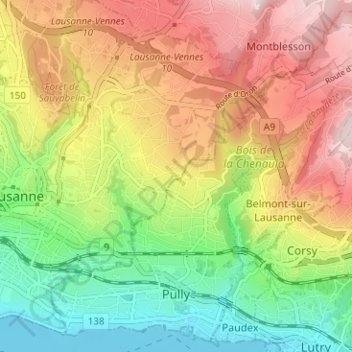
Naam: Topografische kaart Pully, hoogte, reliëf.
Locatie: Pully, District de Lavaux-Oron, Vaud, Switzerland (46.50392 6.63934 46.54464 6.70218)
Gemiddelde hoogte: 578 m
Minimale hoogte: 369 m
Maximale hoogte: 818 m
The municipality stretches from Lake Geneva to the Jorat and includes the peak of Monts-de-Pully at an elevation of 806 m (2,644 ft). It consists of the village section of Chamblandes, La Perraudettaz, Port, Rochettaz and La Rosiaz.
Andere topografische kaarten
Klik op een kaart om zijn topografie, zijn hoogte en zijn reliëf te bekijken.
Chexbres
Switzerland > Vaud > District de Lavaux-Oron > Chexbres
Chexbres, District de Lavaux-Oron, Vaud, 1071, Switzerland
Gemiddelde hoogte: 579 m