
Topografische kaart Cambridge
Klik op de kaart om de hoogte weer te geven.
Cambridge
The city, like most of the UK, has a maritime climate highly influenced by the Gulf Stream. Located in the driest region of Britain, Cambridge's rainfall averages around 570 mm (22.44 in) per year, around half the national average, The driest recent year was in 2011 with 380.4 mm (14.98 in) of rain at the Botanic Garden and 347.2 mm (13.67 in) at the NIAB site. This is just below the semi-arid precipitation threshold for the area, which is 350mm of annual precipitation. Conversely, 2012 was the wettest year on record, with 812.7 mm (32.00 in) reported. Snowfall accumulations are usually small, in part because of Cambridge's low elevation, and low precipitation tendency during transitional snow events.
Over deze kaart
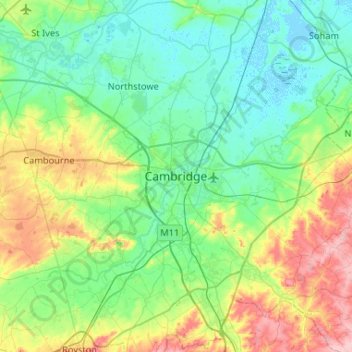
Naam: Topografische kaart Cambridge, hoogte, reliëf.
Gemiddelde hoogte: 33 m
Minimale hoogte: -4 m
Maximale hoogte: 130 m
Andere topografische kaarten
Klik op een kaart om zijn topografie, zijn hoogte en zijn reliëf te bekijken.
Ely
United Kingdom > England > Cambridgeshire
Ely is built on a 23-square-mile (60 km2) Kimmeridge Clay island which, at 85 feet (26 m), is the highest land in the Fens. It was due to this topography that Ely was not waterlogged like the surrounding Fenland, and was an island separated from the mainland. Major rivers including the Witham, Welland, Nene…
Gemiddelde hoogte: 4 m
Little Thetford
United Kingdom > England > Cambridgeshire > East Cambridgeshire
Gemiddelde hoogte: 5 m
Little Abington
United Kingdom > England > Cambridgeshire > South Cambridgeshire
Gemiddelde hoogte: 46 m
River Great Ouse or Ely Ouse
United Kingdom > England > Cambridgeshire > East Cambridgeshire > Soham > Stuntney
Gemiddelde hoogte: 4 m
Brampton
United Kingdom > England > Cambridgeshire > Huntingdonshire > Brampton
Gemiddelde hoogte: 22 m
West Wratting
United Kingdom > England > Cambridgeshire > South Cambridgeshire
Gemiddelde hoogte: 92 m
Westley Waterless
United Kingdom > England > Cambridgeshire > East Cambridgeshire
Gemiddelde hoogte: 92 m
Hinchingbrooke Country Park
United Kingdom > England > Cambridgeshire > Huntingdonshire > Huntingdon > Brampton
Gemiddelde hoogte: 16 m
Kimbolton
United Kingdom > England > Cambridgeshire > Huntingdonshire > Kimbolton
Gemiddelde hoogte: 54 m
Cambridge
United Kingdom > England > Cambridgeshire
The city, like most of the UK, has a maritime climate highly influenced by the Gulf Stream. Located in the driest region of Britain, Cambridge's rainfall averages around 570 mm (22.44 in) per year, around half the national average, The driest recent year was in 2011 with 380.4 mm (14.98 in) of rain at the…
Gemiddelde hoogte: 18 m
Great Abington
United Kingdom > England > Cambridgeshire > South Cambridgeshire
Gemiddelde hoogte: 55 m
Great Shelford
United Kingdom > England > Cambridgeshire > South Cambridgeshire
Gemiddelde hoogte: 22 m
Bluntisham
United Kingdom > England > Cambridgeshire > Huntingdonshire > Bluntisham
Gemiddelde hoogte: 12 m
Stretham
United Kingdom > England > Cambridgeshire > East Cambridgeshire > Stretham
Gemiddelde hoogte: 4 m
West Wickham
United Kingdom > England > Cambridgeshire > South Cambridgeshire
Gemiddelde hoogte: 103 m
Kings Ripton
United Kingdom > England > Cambridgeshire > Huntingdonshire > Kings Ripton
Gemiddelde hoogte: 34 m
Papworth Everard
United Kingdom > England > Cambridgeshire > South Cambridgeshire
Gemiddelde hoogte: 51 m
Chittering
United Kingdom > England > Cambridgeshire > South Cambridgeshire > Waterbeach
Gemiddelde hoogte: 3 m