
Topografische kaart Cetina
Interactieve kaart
Klik op de kaart om de hoogte weer te geven.
Cetina
Cetina is a municipality in the province of Zaragoza, Aragon. It is situated at an altitude of 666 metres (2,185 ft) in the south east of the province, in the Comunidad de Calatayud, some 176 kilometres (109 mi) north east of Madrid and 98 kilometres (61 mi) south west of Zaragoza. The population in 2011 was 687.
Over deze kaart
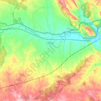
Naam: Topografische kaart Cetina, hoogte, reliëf.
Locatie: Cetina, Comunidad de Calatayud, Zaragoza, Aragon, 50292, Spain (41.21193 -2.01731 41.34991 -1.92128)
Gemiddelde hoogte: 786 m
Minimale hoogte: 649 m
Maximale hoogte: 991 m