
Topografische kaart Aspropyrgos
Interactieve kaart
Klik op de kaart om de hoogte weer te geven.
Over deze kaart
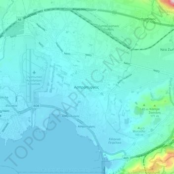
Naam: Topografische kaart Aspropyrgos, hoogte, reliëf.
Gemiddelde hoogte: 53 m
Minimale hoogte: -5 m
Maximale hoogte: 536 m
Andere topografische kaarten
Klik op een kaart om zijn topografie, zijn hoogte en zijn reliëf te bekijken.
Municipal Unit of Ano Liosia
Greece > Attica > Regional Unit of West Attica
Municipal Unit of Ano Liosia, Municipality of Fyli, Regional Unit of West Attica, Attica, Greece
Gemiddelde hoogte: 356 m
Vilia
Greece > Attica > Regional Unit of West Attica > Municipal Unit of Vilia
Vilia, Municipal Unit of Vilia, Municipality of Mandra-Eidyllia, Regional Unit of West Attica, Attica, 190 12, Greece
Gemiddelde hoogte: 604 m
Psatha
Greece > Attica > Regional Unit of West Attica > Municipal Unit of Vilia > Psatha
Psatha, Community of Vilia, Municipal Unit of Vilia, Municipality of Mandra-Eidyllia, Regional Unit of West Attica, Attica, 190 12, Greece
Gemiddelde hoogte: 79 m
Eleusis
Greece > Attica > Regional Unit of West Attica > Municipal Unit of Elefsina
Eleusis, Municipal Unit of Elefsina, Municipality of Elefsina, Regional Unit of West Attica, Attica, 192 00, Greece
Gemiddelde hoogte: 30 m