
Topografische kaart Marchissy
Interactieve kaart
Klik op de kaart om de hoogte weer te geven.
Over deze kaart
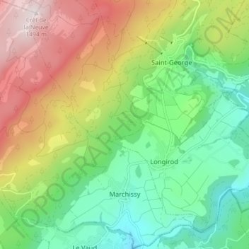
Naam: Topografische kaart Marchissy, hoogte, reliëf.
Locatie: Marchissy, District de Nyon, Vaud, 1261, Switzerland (46.47725 6.19685 46.52594 6.26743)
Gemiddelde hoogte: 1.018 m
Minimale hoogte: 721 m
Maximale hoogte: 1.490 m
Andere topografische kaarten
Klik op een kaart om zijn topografie, zijn hoogte en zijn reliëf te bekijken.
Vich
Switzerland > Vaud > District de Nyon
Vich, District de Nyon, Vaud, 1267, Switzerland
Gemiddelde hoogte: 474 m
Genolier
Switzerland > Vaud > District de Nyon
Genolier, District de Nyon, Vaud, 1272, Switzerland
Gemiddelde hoogte: 564 m
Nyon
Switzerland > Vaud > District de Nyon
Nyon, District de Nyon, Vaud, 1260, Switzerland
Gemiddelde hoogte: 404 m