
Doe een donatie
Rust jezelf uit voor je volgende avontuur:
Als Amazon-partner verdient deze site een commissie op in aanmerking komende aankopen, zonder extra kosten voor jou.
Topografische kaart Schuylkill Haven
Klik op de kaart om de hoogte weer te geven.
Doe een donatie
Rust jezelf uit voor je volgende avontuur:
Als Amazon-partner verdient deze site een commissie op in aanmerking komende aankopen, zonder extra kosten voor jou.
Schuylkill Haven
Schuylkill Haven was developed around the Schuylkill River, which flows through the town entering northwest of Island Park (near Fritz Reed Avenue) and exiting at the southeastern border. he elevation at the river in the borough is approximately 490 feet (150 m) above sea level. Farther from the river, the borough extends up numerous hills, reaching its highest elevation of about 700 feet (210 m) above sea level near the top of Avenue C.
Doe een donatie
Rust jezelf uit voor je volgende avontuur:
Als Amazon-partner verdient deze site een commissie op in aanmerking komende aankopen, zonder extra kosten voor jou.
Over deze kaart
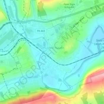
Naam: Topografische kaart Schuylkill Haven, hoogte, reliëf.
Gemiddelde hoogte: 184 m
Minimale hoogte: 147 m
Maximale hoogte: 287 m
Doe een donatie
Rust jezelf uit voor je volgende avontuur:
Als Amazon-partner verdient deze site een commissie op in aanmerking komende aankopen, zonder extra kosten voor jou.
Andere topografische kaarten
Klik op een kaart om zijn topografie, zijn hoogte en zijn reliëf te bekijken.
Park Place
United States > Pennsylvania > Schuylkill County > Mahanoy Township
Gemiddelde hoogte: 515 m
Andreas
United States > Pennsylvania > Schuylkill County > West Penn Township
Gemiddelde hoogte: 250 m
Doe een donatie
Rust jezelf uit voor je volgende avontuur:
Als Amazon-partner verdient deze site een commissie op in aanmerking komende aankopen, zonder extra kosten voor jou.
Blue Mountain
United States > Pennsylvania > Schuylkill County > Washington Township
The ridge of Blue Mountain runs for 150 miles (240 km) through Pennsylvania, reaching an elevation of 2,270 feet (690 m) above sea level just north of the Pennsylvania Turnpike, near the borough of Newburg. Most of the ridgecrest, however, only reaches between 1,400 and 1,700 feet (430 and 520 m) in elevation.…
Gemiddelde hoogte: 226 m
Snyders
United States > Pennsylvania > Schuylkill County > West Penn Township
Gemiddelde hoogte: 242 m
Andreas
United States > Pennsylvania > Schuylkill County > West Penn Township
Gemiddelde hoogte: 250 m
Doe een donatie
Rust jezelf uit voor je volgende avontuur:
Als Amazon-partner verdient deze site een commissie op in aanmerking komende aankopen, zonder extra kosten voor jou.
Blue Mountain
United States > Pennsylvania > Schuylkill County > Washington Township
The ridge of Blue Mountain runs for 150 miles (240 km) through Pennsylvania, reaching an elevation of 2,270 feet (690 m) above sea level just north of the Pennsylvania Turnpike, near the borough of Newburg. Most of the ridgecrest, however, only reaches between 1,400 and 1,700 feet (430 and 520 m) in elevation.…
Gemiddelde hoogte: 226 m
Irving
United States > Pennsylvania > Schuylkill County > Pine Grove Township
Gemiddelde hoogte: 199 m
Doe een donatie
Rust jezelf uit voor je volgende avontuur:
Als Amazon-partner verdient deze site een commissie op in aanmerking komende aankopen, zonder extra kosten voor jou.
Blue Mountain
United States > Pennsylvania > Schuylkill County > Washington Township
The ridge of Blue Mountain runs for 150 miles (240 km) through Pennsylvania, reaching an elevation of 2,270 feet (690 m) above sea level just north of the Pennsylvania Turnpike, near the borough of Newburg. Most of the ridgecrest, however, only reaches between 1,400 and 1,700 feet (430 and 520 m) in elevation.…
Gemiddelde hoogte: 226 m
Nuremberg
United States > Pennsylvania > Schuylkill County > North Union Township
Gemiddelde hoogte: 377 m