
Topografische kaart Monemvasia
Interactieve kaart
Klik op de kaart om de hoogte weer te geven.
Over deze kaart
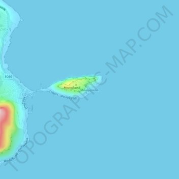
Naam: Topografische kaart Monemvasia, hoogte, reliëf.
Gemiddelde hoogte: 7 m
Minimale hoogte: -2 m
Maximale hoogte: 268 m
Andere topografische kaarten
Klik op een kaart om zijn topografie, zijn hoogte en zijn reliëf te bekijken.
Ευρώτας
Greece > Peloponnese, Western Greece and the Ionian > Laconia Regional Unit
Ευρώτας, Laconia Regional Unit, Peloponnese Region, Peloponnese, Western Greece and the Ionian, Greece
Gemiddelde hoogte: 656 m
Municipal Unit of Sparta
Greece > Peloponnese, Western Greece and the Ionian > Laconia Regional Unit
Municipal Unit of Sparta, Municipality of Sparta, Laconia Regional Unit, Peloponnese Region, Peloponnese, Western Greece and the Ionian, 231 00, Greece
Gemiddelde hoogte: 450 m
Lagia
Greece > Peloponnese, Western Greece and the Ionian > Laconia Regional Unit > East Mani Municipal Unit
Lagia, East Mani Municipal Unit, Municipality of East Mani, Laconia Regional Unit, Peloponnese Region, Peloponnese, Western Greece and the Ionian, 230 71, Greece
Gemiddelde hoogte: 317 m
Sparta
Greece > Peloponnese, Western Greece and the Ionian > Laconia Regional Unit
Sparta, Municipality of Sparta, Laconia Regional Unit, Peloponnese Region, Peloponnese, Western Greece and the Ionian, 231 00, Greece
Gemiddelde hoogte: 198 m
Sparta
Greece > Peloponnese, Western Greece and the Ionian > Laconia Regional Unit > Municipality of Sparta > Χαρίσιο
Sparta, Τριακοσίων, Χαρίσιο, Municipality of Sparta, Laconia Regional Unit, Peloponnese Region, Peloponnese, Western Greece and the Ionian, 23100, Greece
Gemiddelde hoogte: 214 m
Municipality of Sparta
Greece > Peloponnese, Western Greece and the Ionian > Laconia Regional Unit
Municipality of Sparta, Laconia Regional Unit, Peloponnese Region, Peloponnese, Western Greece and the Ionian, Greece
Gemiddelde hoogte: 699 m
Molai
Greece > Peloponnese, Western Greece and the Ionian > Laconia Regional Unit > Molai
Molai, Municipality of Monemvasia, Laconia Regional Unit, Peloponnese Region, Peloponnese, Western Greece and the Ionian, 230 52, Greece
Gemiddelde hoogte: 260 m