
Topografische kaart Puntledge
Interactieve kaart
Klik op de kaart om de hoogte weer te geven.
Over deze kaart
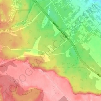
Naam: Topografische kaart Puntledge, hoogte, reliëf.
Gemiddelde hoogte: 115 m
Minimale hoogte: 46 m
Maximale hoogte: 174 m
Andere topografische kaarten
Klik op een kaart om zijn topografie, zijn hoogte en zijn reliëf te bekijken.
Nymph Falls
Canada > British Columbia > Comox Valley Regional District > Area C (Puntledge/Black Creek)
Nymph Falls, Area C (Puntledge/Black Creek), Comox Valley Regional District, British Columbia, V9J 1R5, Canada
Gemiddelde hoogte: 128 m
Croteau Lake
Canada > British Columbia > Comox Valley Regional District > Area C (Puntledge/Black Creek)
Croteau Lake, Area C (Puntledge/Black Creek), Comox Valley Regional District, British Columbia, Canada
Gemiddelde hoogte: 1.195 m
Forbidden Plateau
Canada > British Columbia > Comox Valley Regional District > Area C (Puntledge/Black Creek)
Forbidden Plateau, Area C (Puntledge/Black Creek), Comox Valley Regional District, British Columbia, Canada
Gemiddelde hoogte: 1.041 m
Miracle Beach
Canada > British Columbia > Comox Valley Regional District > Area C (Puntledge/Black Creek) > Miracle Beach
Miracle Beach, Area C (Puntledge/Black Creek), Comox Valley Regional District, British Columbia, V9J 1A0, Canada
Gemiddelde hoogte: 30 m
MacAulay Heights
Canada > British Columbia > Comox Valley Regional District > Area C (Puntledge/Black Creek) > MacAulay Heights
MacAulay Heights, Area C (Puntledge/Black Creek), Comox Valley Regional District, British Columbia, Canada
Gemiddelde hoogte: 94 m
Mount Becher
Canada > British Columbia > Comox Valley Regional District > Area C (Puntledge/Black Creek)
Mount Becher, Area C (Puntledge/Black Creek), Comox Valley Regional District, British Columbia, Canada
Gemiddelde hoogte: 1.035 m