
Topografische kaart Eperrais
Interactieve kaart
Klik op de kaart om de hoogte weer te geven.
Over deze kaart
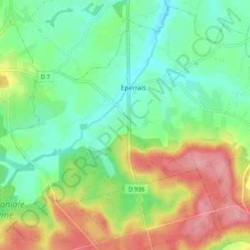
Naam: Topografische kaart Eperrais, hoogte, reliëf.
Gemiddelde hoogte: 189 m
Minimale hoogte: 148 m
Maximale hoogte: 255 m
Andere topografische kaarten
Klik op een kaart om zijn topografie, zijn hoogte en zijn reliëf te bekijken.
Les Batailles
France > Normandie > Orne > Belforêt-en-Perche
Les Batailles, Le Gué-de-la-Chaîne, Belforêt-en-Perche, Mortagne-au-Perche, Orne, Normandie, France métropolitaine, 61130, France
Gemiddelde hoogte: 184 m
Bouvigny
France > Normandie > Orne > Belforêt-en-Perche
Bouvigny, La Perrière, Belforêt-en-Perche, Mortagne-au-Perche, Orne, Normandie, France métropolitaine, 61360, France
Gemiddelde hoogte: 179 m
Beau Repos
France > Normandie > Orne > Belforêt-en-Perche
Beau Repos, Eperrais, Belforêt-en-Perche, Mortagne-au-Perche, Orne, Normandie, France métropolitaine, 61400, France
Gemiddelde hoogte: 180 m
Sérigny
France > Normandie > Orne > Belforêt-en-Perche
Sérigny, Belforêt-en-Perche, Mortagne-au-Perche, Orne, Normandie, France métropolitaine, 61130, France
Gemiddelde hoogte: 196 m
La Petite Grange
France > Normandie > Orne > Belforêt-en-Perche
La Petite Grange, La Perrière, Belforêt-en-Perche, Mortagne-au-Perche, Orne, Normandie, France métropolitaine, 61360, France
Gemiddelde hoogte: 167 m
Le Champu
France > Normandie > Orne > Belforêt-en-Perche
Le Champu, La Perrière, Belforêt-en-Perche, Mortagne-au-Perche, Orne, Normandie, France métropolitaine, 61360, France
Gemiddelde hoogte: 156 m
La Perrière
France > Normandie > Orne > Belforêt-en-Perche
La Perrière, Belforêt-en-Perche, Mortagne-au-Perche, Orne, Normandie, France métropolitaine, 61360, France
Gemiddelde hoogte: 174 m