
Topografische kaart Rietspruit
Interactieve kaart
Klik op de kaart om de hoogte weer te geven.
Over deze kaart
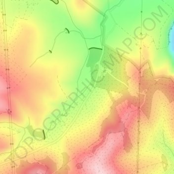
Naam: Topografische kaart Rietspruit, hoogte, reliëf.
Gemiddelde hoogte: 696 m
Minimale hoogte: 562 m
Maximale hoogte: 792 m
Andere topografische kaarten
Klik op een kaart om zijn topografie, zijn hoogte en zijn reliëf te bekijken.
uMngeni River
RSA > KwaZulu-Natal > uMshwathi Local Municipality
uMngeni River, uMshwathi Local Municipality, uMgungundlovu District Municipality, KwaZulu-Natal, RSA
Gemiddelde hoogte: 636 m
Cumberland Nature Reserve
RSA > KwaZulu-Natal > uMshwathi Local Municipality
Cumberland Nature Reserve, Lower Waterfall, uMshwathi Ward 9, uMshwathi Local Municipality, uMgungundlovu District Municipality, KwaZulu-Natal, RSA
Gemiddelde hoogte: 633 m