
Topografische kaart Silverton
Interactieve kaart
Klik op de kaart om de hoogte weer te geven.
Silverton
According to the United States Census Bureau, the town has a total area of 0.8 square miles (2.1 km2), all of it land. Silverton is one of the highest towns in the United States, at 9,318 feet (2,840 m) above sea level. The town is located in San Juan County, the highest county in the United States, with a mean elevation of 11,240 feet (3,430 meters). Silverton sits in a flat area of the Animas River valley and is surrounded by several thirteeners, the highest being Storm Peak, at 13,487 feet. The town is less than 15 miles from seven of Colorado's 53 "fourteeners", i.e., mountain peaks with a summit elevation of at least 14,000 feet (4,300 meters).
Over deze kaart
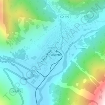
Naam: Topografische kaart Silverton, hoogte, reliëf.
Locatie: Silverton, San Juan County, Colorado, 81433, United States (37.80055 -107.67702 37.82005 -107.65038)
Gemiddelde hoogte: 2.991 m
Minimale hoogte: 2.811 m
Maximale hoogte: 3.661 m
Andere topografische kaarten
Klik op een kaart om zijn topografie, zijn hoogte en zijn reliëf te bekijken.
Coal Bank Pass
United States > Colorado > San Juan County
Coal Bank Pass, elevation 10,640 feet (3,240 meters), is a mountain pass in the San Juan Mountains of western Colorado in the United States. The pass is in the San Juan National Forest.
Gemiddelde hoogte: 3.277 m
Animas Forks
United States > Colorado > San Juan County
Animas Forks is located on a system of roads known as the Alpine Loop. The loop is a 65-mile (105 km) system of unpaved roads which connects the small mountain towns of Lake City, Ouray, and Silverton. Most of the land in the area is managed by either the U.S. Forest Service or the Bureau of Land Management.…
Gemiddelde hoogte: 3.636 m