Geolokaliseren

Topografische kaart Rockingham County

Interactieve kaart

Klik op de kaart om de hoogte weer te geven.

Over deze kaart

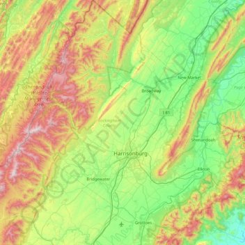
Naam: Topografische kaart Rockingham County, hoogte, reliëf.

Locatie: Rockingham County, Virginia, VS (38.20818 -79.22141 38.85010 -78.48708)

Gemiddelde hoogte: 525 m

Minimale hoogte: 138 m

Maximale hoogte: 1.320 m

Andere topografische kaarten

Klik op een kaart om zijn topografie, zijn hoogte en zijn reliëf te bekijken.

Greenfields

VS > Virginia > Greenfields

Greenfields, Albemarle County, Virginia, 22908, VS

Gemiddelde hoogte: 136 m

Arlington

VS > Virginia > Arlington

Arlington, Arlington County, Virginia, VS

Gemiddelde hoogte: 51 m

Newport News City

VS > Virginia

Newport News City, Virginia, VS

Gemiddelde hoogte: 6 m

Valley Oaks

VS > Virginia > Valley Oaks

Valley Oaks, Hanover County, Virginia, VS

Gemiddelde hoogte: 50 m

Rosewell

VS > Virginia > Rosewell

Rosewell, Gloucester County, Virginia, VS

Gemiddelde hoogte: 4 m

Dilbeck

VS > Virginia > Dilbeck

Dilbeck, Shenandoah County, Virginia, VS

Gemiddelde hoogte: 317 m

Adams Peak

VS > Virginia

Adams Peak, Rockbridge County, Virginia, VS

Gemiddelde hoogte: 611 m

Elk Island

VS > Virginia

Elk Island, Goochland County, Virginia, VS

Gemiddelde hoogte: 79 m

Crozet

VS > Virginia > Crozet

Crozet, Saint George Street, Crozet, Albemarle County, Virginia, 22932, VS

Gemiddelde hoogte: 234 m

Dominion

VS > Virginia > Dominion

Dominion, Lee County, Virginia, 24282, VS

Gemiddelde hoogte: 600 m

Wythe County

VS > Virginia

Wythe County, Virginia, VS

Gemiddelde hoogte: 797 m

Richmond City

VS > Virginia > Richmond City

Richmond, Richmond City, Virginia, 23298, VS

Gemiddelde hoogte: 53 m

Key West

VS > Virginia > Key West

Key West, Albemarle County, Virginia, 22909, VS

Gemiddelde hoogte: 145 m