
Topografische kaart Schnecksville
Interactieve kaart
Klik op de kaart om de hoogte weer te geven.
Schnecksville
According to the U.S. Census Bureau, Schnecksville has a total area of 2.7 square miles (7.0 km2), of which 0.01 square miles (0.02 km2), or 0.28%, are water. Schnecksville sits on a ridge at an elevation of about 660 feet (200 m) above sea level. To the west, water flows to Jordan Creek, while to the east water flows to Coplay Creek. Both creeks are southeast-flowing tributaries of the Lehigh River and part of the Delaware River watershed.
Over deze kaart
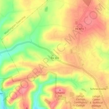
Naam: Topografische kaart Schnecksville, hoogte, reliëf.
Gemiddelde hoogte: 197 m
Minimale hoogte: 144 m
Maximale hoogte: 229 m
Andere topografische kaarten
Klik op een kaart om zijn topografie, zijn hoogte en zijn reliëf te bekijken.
Orefield
United States > Pennsylvania > Lehigh County > North Whitehall Township
Gemiddelde hoogte: 141 m
Ormrod
United States > Pennsylvania > Lehigh County > North Whitehall Township
Gemiddelde hoogte: 148 m