
Topografische kaart McCloud
Interactieve kaart
Klik op de kaart om de hoogte weer te geven.
Over deze kaart
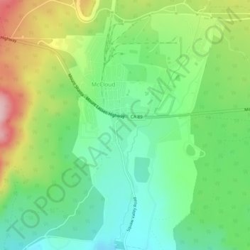
Naam: Topografische kaart McCloud, hoogte, reliëf.
Gemiddelde hoogte: 1.010 m
Minimale hoogte: 932 m
Maximale hoogte: 1.148 m
McCloud is located at 41°15′17″N 122°8′11″W / 41.25472°N 122.13639°W / 41.25472; -122.13639 (41.254682, -122.136321) on the southern slope of Mount Shasta, at an elevation of 3,271 feet (997 m) above sea level.