Topografische kaart Mississauga
Klik op de kaart om de hoogte weer te geven.
Mississauga
The shoreline of former Glacial Lake Iroquois roughly follows the Dundas Street alignment, although it is not noticeable in some places but is more prominent in others, such as the site of the former brickyard (Shoreline Dr. near Mavis Rd.). The ancient shoreline promontory affords a clear view of downtown Toronto and Lake Ontario on clear days. The land in Mississauga ranges from a maximum elevation of 214 m (699 ft) above sea level in the far west near the Hwy. 407/401 junction, to a minimum elevation at the Lake Ontario shore of 76 m (249 ft) above sea level.
Over deze kaart
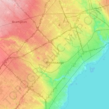
Naam: Topografische kaart Mississauga, hoogte, reliëf.
Locatie: Mississauga, Peel Region, Golden Horseshoe, Ontario, Canada (43.47899 -79.81032 43.73706 -79.53856)
Gemiddelde hoogte: 151 m
Minimale hoogte: 70 m
Maximale hoogte: 263 m
Andere topografische kaarten
Klik op een kaart om zijn topografie, zijn hoogte en zijn reliëf te bekijken.