
Topografische kaart Heydon
Klik op de kaart om de hoogte weer te geven.
Heydon
By the village green there is an 18th-century public house – The Earle Arms – which is grade II listed and has a "Regionally Important Historic Interior". It was until circa 1845 called the Lion and Lamb. It is believed that a pub has existed at this location since the 16th century, and was a coaching inn. The front elevation of the building features a wood sculpture of Mary Read, an 18th-century pirate, believed to originate from that century.
Over deze kaart
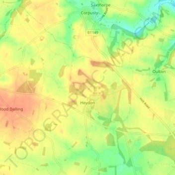
Naam: Topografische kaart Heydon, hoogte, reliëf.
Locatie: Heydon, Broadland, Norfolk, England, United Kingdom (52.78334 1.09536 52.82932 1.17642)
Gemiddelde hoogte: 44 m
Minimale hoogte: 20 m
Maximale hoogte: 60 m
Andere topografische kaarten
Klik op een kaart om zijn topografie, zijn hoogte en zijn reliëf te bekijken.
Great Witchingham Village Hall Park
United Kingdom > England > Norfolk > Broadland > Lenwade > Great Witchingham
Gemiddelde hoogte: 26 m
Haveringland Lake
United Kingdom > England > Norfolk > Broadland > Haveringland
Gemiddelde hoogte: 39 m