
Topografische kaart Murphy
Interactieve kaart
Klik op de kaart om de hoogte weer te geven.
Over deze kaart
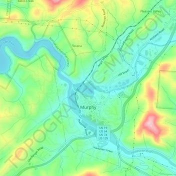
Naam: Topografische kaart Murphy, hoogte, reliëf.
Locatie: Murphy, Cherokee County, North Carolina, United States (35.07100 -84.04487 35.11326 -84.00244)
Gemiddelde hoogte: 514 m
Minimale hoogte: 448 m
Maximale hoogte: 648 m
Murphy is located in southwestern North Carolina, approximately halfway between Atlanta, Georgia and Knoxville, Tennessee. The topography consists of gentle rolling hills and mountains with tall peaks, including ranges from 1800 ft to more than 5000 ft elevation. The location in the Blue Ridge Mountains has helped the community retain a fairly rural character, surrounded by wildlife such as bear, deer, fox and recently reintroduced elk.
Andere topografische kaarten
Klik op een kaart om zijn topografie, zijn hoogte en zijn reliëf te bekijken.
Rhodo
United States > North Carolina > Cherokee County
Rhodo, Cherokee County, North Carolina, United States
Gemiddelde hoogte: 819 m
Hanging Dog Mountain
United States > North Carolina > Cherokee County
Hanging Dog Mountain, Cherokee County, North Carolina, United States
Gemiddelde hoogte: 962 m
Wolf Creek
United States > North Carolina > Cherokee County
Wolf Creek, Cherokee County, North Carolina, United States
Gemiddelde hoogte: 623 m
Andrews
United States > North Carolina > Cherokee County
Andrews, Cherokee County, North Carolina, 28901, United States
Gemiddelde hoogte: 593 m
Murphy
United States > North Carolina > Cherokee County > Murphy
Murphy, Cherokee County, North Carolina, United States
Gemiddelde hoogte: 528 m
Canedy Mountain
United States > North Carolina > Cherokee County
Canedy Mountain, Cherokee County, North Carolina, United States
Gemiddelde hoogte: 616 m
Vance Mountain
United States > North Carolina > Cherokee County
Vance Mountain, Cherokee County, North Carolina, United States
Gemiddelde hoogte: 630 m
Jones Mill
United States > North Carolina > Cherokee County
Jones Mill, Cherokee County, North Carolina, United States
Gemiddelde hoogte: 702 m
Wehutty
United States > North Carolina > Cherokee County
Wehutty, Cherokee County, North Carolina, United States
Gemiddelde hoogte: 529 m
Marble
United States > North Carolina > Cherokee County
Marble, Cherokee County, North Carolina, 28905, United States
Gemiddelde hoogte: 571 m
Tipton Knob
United States > North Carolina > Cherokee County
Tipton Knob, Cherokee County, North Carolina, United States
Gemiddelde hoogte: 936 m
Hothouse
United States > North Carolina > Cherokee County > Hothouse
Hothouse, Cherokee County, North Carolina, United States
Gemiddelde hoogte: 624 m
Leatherwood Mountain
United States > North Carolina > Cherokee County > Andrews
Leatherwood Mountain, Andrews, Cherokee County, North Carolina, 28901, United States
Gemiddelde hoogte: 570 m
Hiwassee Village
United States > North Carolina > Cherokee County > Hiwassee Village
Hiwassee Village, Cherokee County, North Carolina, United States
Gemiddelde hoogte: 481 m
Topton
United States > North Carolina > Cherokee County
Topton, Cherokee County, North Carolina, United States
Gemiddelde hoogte: 980 m