
Doe een donatie
Rust jezelf uit voor je volgende avontuur:
Als Amazon-partner verdient deze site een commissie op in aanmerking komende aankopen, zonder extra kosten voor jou.
Topografische kaart Zheleznogorsk
Klik op de kaart om de hoogte weer te geven.
Doe een donatie
Rust jezelf uit voor je volgende avontuur:
Als Amazon-partner verdient deze site een commissie op in aanmerking komende aankopen, zonder extra kosten voor jou.
Zheleznogorsk
Zheleznogorsk is located 35 km north of Krasnoyarsk, in the foothills of the Atamanovsky Ridge, the spurs of the Sayan Mountains. The climate of the city, as in Krasnoyarsk, is Dfb according to Köppen. The average annual temperature is 2.2 °C or 36 °F. The city is located far from the southern border of permafrost due to the warmer climate than in most of Eastern Siberia. Mixed forests grow in the city itself, with a predominance of conifers, especially in mountainous areas. The city is also partially located in the steppe zone. Due to the high continentality of the climate, there are large temperature differences during the day and at night, as well as between winter and summer. At the same time, daytime temperatures are often higher than the average in Siberia, and nighttime temperatures from time to time are below average. The period with a positive daily average temperature slightly exceeds the period with a negative one. The maximum and minimum temperature ranges from -46°C (-51°F) to +39°C (102°F) degrees. The climate of the city is considered warmer than in Krasnoyarsk itself due to the lower elevation difference and greater penetration of warm western and southern air masses into the West Siberian Plain and the Yenisei Valley.
Doe een donatie
Rust jezelf uit voor je volgende avontuur:
Als Amazon-partner verdient deze site een commissie op in aanmerking komende aankopen, zonder extra kosten voor jou.
Over deze kaart
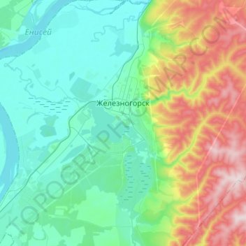
Naam: Topografische kaart Zheleznogorsk, hoogte, reliëf.
Gemiddelde hoogte: 220 m
Minimale hoogte: 116 m
Maximale hoogte: 523 m
Doe een donatie
Rust jezelf uit voor je volgende avontuur:
Als Amazon-partner verdient deze site een commissie op in aanmerking komende aankopen, zonder extra kosten voor jou.