
Topografische kaart Marousi
Interactieve kaart
Klik op de kaart om de hoogte weer te geven.
Over deze kaart
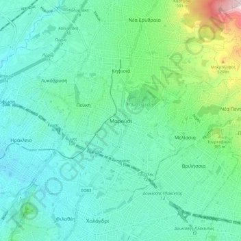
Naam: Topografische kaart Marousi, hoogte, reliëf.
Gemiddelde hoogte: 257 m
Minimale hoogte: 125 m
Maximale hoogte: 783 m
Andere topografische kaarten
Klik op een kaart om zijn topografie, zijn hoogte en zijn reliëf te bekijken.
Municipal Unit of Neo Psychiko
Greece > Attica > Regional Unit of North Athens
Municipal Unit of Neo Psychiko, Municipality of Filothei - Psychiko, Regional Unit of North Athens, Attica, 154 51, Greece
Gemiddelde hoogte: 191 m
Chalandri
Greece > Attica > Regional Unit of North Athens
Chalandri, Municipality of Chalandri, Regional Unit of North Athens, Attica, 152 32, Greece
Gemiddelde hoogte: 222 m
Penteli Municipal Unit
Greece > Attica > Regional Unit of North Athens
Penteli Municipal Unit, Municipality of Penteli, Regional Unit of North Athens, Attica, 152 36, Greece
Gemiddelde hoogte: 422 m
Olympus
Greece > Attica > Regional Unit of North Athens > Municipal Unit of Psychiko
Olympus, Municipal Unit of Psychiko, Municipality of Filothei - Psychiko, Regional Unit of North Athens, Attica, 154 52, Greece
Gemiddelde hoogte: 204 m
Municipality of Marousi
Greece > Attica > Regional Unit of North Athens
Municipality of Marousi, Regional Unit of North Athens, Attica, Greece
Gemiddelde hoogte: 224 m
Municipality of Metamorfosi
Greece > Attica > Regional Unit of North Athens
Municipality of Metamorfosi, Regional Unit of North Athens, Attica, Greece
Gemiddelde hoogte: 174 m
Nea Penteli Municipal Unit
Greece > Attica > Regional Unit of North Athens > Nea Penteli Municipal Unit
Nea Penteli Municipal Unit, Municipality of Penteli, Regional Unit of North Athens, Attica, Greece
Gemiddelde hoogte: 496 m
Municipality of Chalandri
Greece > Attica > Regional Unit of North Athens > Municipality of Chalandri
Municipality of Chalandri, Regional Unit of North Athens, Attica, Greece
Gemiddelde hoogte: 208 m
Municipality of Kifisia
Greece > Attica > Regional Unit of North Athens
Municipality of Kifisia, Regional Unit of North Athens, Attica, Greece
Gemiddelde hoogte: 342 m