
Doe een donatie
Rust jezelf uit voor je volgende avontuur:
Als Amazon-partner verdient deze site een commissie op in aanmerking komende aankopen, zonder extra kosten voor jou.
Topografische kaart Deeth
Klik op de kaart om de hoogte weer te geven.
Doe een donatie
Rust jezelf uit voor je volgende avontuur:
Als Amazon-partner verdient deze site een commissie op in aanmerking komende aankopen, zonder extra kosten voor jou.
Over deze kaart
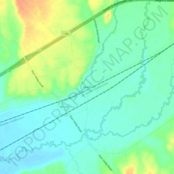
Naam: Topografische kaart Deeth, hoogte, reliëf.
Locatie: Deeth, Elko County, Nevada, 89823, United States (41.04603 -115.29467 41.08603 -115.25467)
Gemiddelde hoogte: 1.634 m
Minimale hoogte: 1.620 m
Maximale hoogte: 1.660 m
Doe een donatie
Rust jezelf uit voor je volgende avontuur:
Als Amazon-partner verdient deze site een commissie op in aanmerking komende aankopen, zonder extra kosten voor jou.
Andere topografische kaarten
Klik op een kaart om zijn topografie, zijn hoogte en zijn reliëf te bekijken.
Ruby Mountains
United States > Nevada > Elko County
The Ruby Mountains (Shoshoni: 'Duka Doya', meaning “Snowcapped”) are a mountain range, primarily located within Elko County with a small extension into White Pine County, in Nevada, United States. Most of the range is included within the Humboldt-Toiyabe National Forest. The range reaches a maximum…
Gemiddelde hoogte: 1.962 m
Wells
United States > Nevada > Elko County
According to the United States Census Bureau, the city has a total area of 6.9 square miles (18 km2), all land, at an elevation of 5,630 feet (1,720 m).
Gemiddelde hoogte: 1.744 m
Doe een donatie
Rust jezelf uit voor je volgende avontuur:
Als Amazon-partner verdient deze site een commissie op in aanmerking komende aankopen, zonder extra kosten voor jou.
Carlin
United States > Nevada > Elko County
Carlin is a city in Elko County of northeast Nevada, United States, and 23 miles (37 km) west of the city of Elko. As of the 2010 census, its population was 2,368, up from 2,161 at the 2000 census. Carlin sits along Interstate 80 at an elevation of approximately 4,900 feet (1,500 m). The city was named for…
Gemiddelde hoogte: 1.522 m