
Topografische kaart Arambagh
Interactieve kaart
Klik op de kaart om de hoogte weer te geven.
Over deze kaart
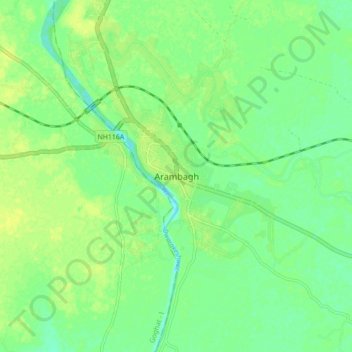
Naam: Topografische kaart Arambagh, hoogte, reliëf.
Gemiddelde hoogte: 17 m
Minimale hoogte: 8 m
Maximale hoogte: 25 m
Arambagh is located at 22°53′N 87°47′E / 22.88°N 87.78°E / 22.88; 87.78. It has an average elevation of 15 metres (118 feet). The town is situated on the link Road (state highway-2) 81Km north-west of Kolkata, 27 Km north-west of Tarakeswar, 39 Km south-east of Bardhaman. It is located on the bank of the Dwarakeswar River.
Andere topografische kaarten
Klik op een kaart om zijn topografie, zijn hoogte en zijn reliëf te bekijken.