
Topografische kaart Río Chinchiná
Interactieve kaart
Klik op de kaart om de hoogte weer te geven.
Over deze kaart
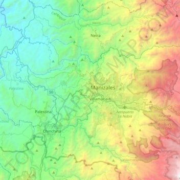
Naam: Topografische kaart Río Chinchiná, hoogte, reliëf.
Locatie: Río Chinchiná, Villamaría, Centrosur, Caldas, 170008, Colombia (4.98281 -75.67920 5.14053 -75.33028)
Gemiddelde hoogte: 1.966 m
Minimale hoogte: 749 m
Maximale hoogte: 4.732 m
Andere topografische kaarten
Klik op een kaart om zijn topografie, zijn hoogte en zijn reliëf te bekijken.
Las Brisas
Colombia > Caldas > Villamaría
Las Brisas, Villamaría, Centrosur, Caldas, RAP del Agua y la Montaña, 176001, Colombia
Gemiddelde hoogte: 2.038 m
Cabecera Municipal Villamaría
Colombia > Caldas > Villamaría
Cabecera Municipal Villamaría, Villamaría, Centrosur, Caldas, RAP del Agua y la Montaña, 176001, Colombia
Gemiddelde hoogte: 1.950 m