
Topografische kaart Ben Cat Town
Interactieve kaart
Klik op de kaart om de hoogte weer te geven.
Ben Cat Town
Ben Cat is in the transition zone from the Trường Sơn range in the north of the central highland to the southern plain, so the general topography of the whole town is relatively high from 30 to 35m above sea level in the north and lower to the south. In the south, the climate belongs to the tropical savanna region, there is little flooding and the average annual rainfall is about 1,500-2,500mm, the average monthly temperature is 32°C during the day and 23°C at night, the hottest month is 36 °C and the coldest month is 16°C. In mid-December, the town often has dense fog in the early morning and ends at 7-8am.
Over deze kaart
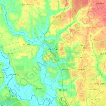
Naam: Topografische kaart Ben Cat Town, hoogte, reliëf.
Locatie: Ben Cat Town, Bình Dương Province, 75900, Vietnam (11.03422 106.50770 11.22963 106.69419)
Gemiddelde hoogte: 25 m
Minimale hoogte: -5 m
Maximale hoogte: 61 m
Andere topografische kaarten
Klik op een kaart om zijn topografie, zijn hoogte en zijn reliëf te bekijken.