
Topografische kaart Suikerbosrand Nature Reserve
Interactieve kaart
Klik op de kaart om de hoogte weer te geven.
Over deze kaart
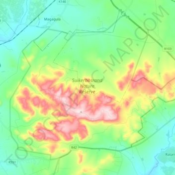
Naam: Topografische kaart Suikerbosrand Nature Reserve, hoogte, reliëf.
Gemiddelde hoogte: 1.620 m
Minimale hoogte: 1.484 m
Maximale hoogte: 1.912 m
Andere topografische kaarten
Klik op een kaart om zijn topografie, zijn hoogte en zijn reliëf te bekijken.
Midvaal Ward 13
RSA > Gauteng > Midvaal Local Municipality
Midvaal Ward 13, Midvaal Local Municipality, Sedibeng District Municipality, Gauteng, RSA
Gemiddelde hoogte: 1.486 m