
Topografische kaart Waldegrave
Interactieve kaart
Klik op de kaart om de hoogte weer te geven.
Over deze kaart
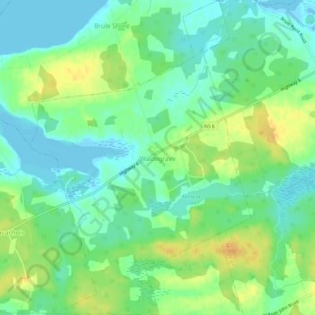
Naam: Topografische kaart Waldegrave, hoogte, reliëf.
Gemiddelde hoogte: 13 m
Minimale hoogte: -3 m
Maximale hoogte: 32 m
Andere topografische kaarten
Klik op een kaart om zijn topografie, zijn hoogte en zijn reliëf te bekijken.
Old Barns
Canada > Nova Scotia > Municipality of Colchester
Old Barns, Municipality of Colchester, Colchester County, Nova Scotia, Canada
Gemiddelde hoogte: 62 m
Balfron
Canada > Nova Scotia > Municipality of Colchester
Balfron, Municipality of Colchester, Colchester County, Nova Scotia, Canada
Gemiddelde hoogte: 43 m
Economy
Canada > Nova Scotia > Municipality of Colchester > Economy
Economy, Municipality of Colchester, Colchester County, Nova Scotia, B0M 1J0, Canada
Gemiddelde hoogte: 93 m
Castlereagh
Canada > Nova Scotia > Municipality of Colchester
Castlereagh, Municipality of Colchester, Colchester County, Nova Scotia, B0M 1G0, Canada
Gemiddelde hoogte: 213 m